The mine plan
Berg is a proposed open-pit copper and molybdenum mine on the slopes of Mt. Ney, in the upper Nanika River watershed. This page sets out what Surge Copper proposes to build, how long each phase lasts, and how many people it employs. Every figure here is the company's own, from its Initial Project Description (IPD) of September 2026.
In brief
Surge Copper plans a single open pit that moves about 118 million tonnes of rock a year on average and up to 200 million tonnes at peak. Ore travels by conveyor to a mill about 400 metres lower, beside the tailings facility, which grinds and floats 120,000 tonnes a day into copper and molybdenum concentrates. Trucks carry the concentrates out over forest service roads. A new 230 kilovolt (kV) line brings power from the BC Hydro grid near Houston. Construction takes three years, operations 28 and closure two; post-closure care lasts until permit conditions are met.
Where the mine sits
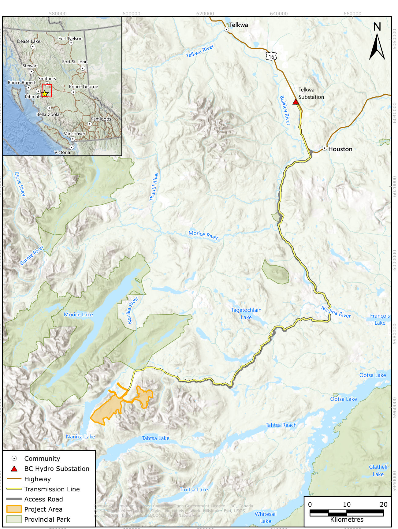
The site is about 80 km southwest of Houston, BC, and is reached by about 116 km of existing forest service roads. It lies within the Wet'suwet'en Yintah (traditional lands), in the territory of the Thin House (Yextsowiten) of the Gilseyhu Clan, and within the asserted traditional territory of the Cheslatta Carrier Nation. Smithers is about 110 km to the north, or about 200 km by road. Source: IPD, p. 1-1; IPD, p. 3-5.
The "Project Area" covers 5,009 hectares, which includes the mine footprint, nearby facilities and a 100-metre buffer. The area lies on the lower slopes of Mt. Ney at elevations from about 1,500 to 2,050 metres above sea level, and the ore body is centred near 1,800 metres. Its nearest edge is about 4 km from Nenikëkh/Nanika-Kidprice Provincial Park and about 5 km from Morice Lake Provincial Park. Source: IPD, p. 3-1; IPD, p. 8-20; IPD, p. 10-12; IPD, p. 3-8.
The deposit and its history
Berg is a porphyry copper and molybdenum deposit. Its metals are spread widely through the rock at relatively low grade, and the mineralized zone reaches the surface. The company states that open-pit mining is therefore the only option, because underground mining "would not be economically effective". Source: IPD, p. 4-4.
Kennecott drilled the deposit in 1965 and 1966, and 119 diamond drill holes totalling 20,127.9 metres had been completed by 1980. Thompson Creek Metals bought the property in 2010, and Surge completed the purchase of a 100% interest from it in January 2024. Berg has never been through an environmental assessment. The current design comes from Surge's 2026 Pre-Feasibility Study (PFS), prepared by Ausenco and Moose Mountain. Source: IPD, p. 3-10; IPD, p. 3-11; IPD, p. 3-5; IPD, p. 4-1; IPD, p. 4-26.
The open pit
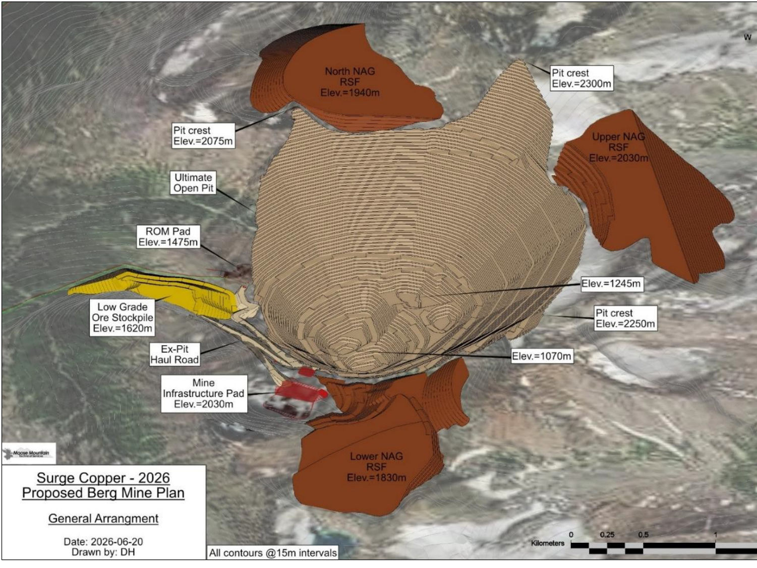
The pit is one final shape mined in six phases, or pushbacks, so that the higher-value parts of the deposit come out early. Mining runs on 15-metre benches with an owner-operated fleet of electric and diesel drills, electric cable shovels, diesel hydraulic shovels and diesel ultra-class haul trucks. The company says electric equipment is used "where equipment is currently available". Source: IPD, p. 4-4.
- Rock moved. Average material movement is 118 million tonnes a year; the peak is about 200 million tonnes a year. Source: IPD, p. 1-1; IPD, p. 4-4.
- Ore and waste. About 1,209 million tonnes of ore and 2,408 million tonnes of waste rock, a strip ratio of 2.0 to 1. The waste figure includes 304 million tonnes stripped before production begins. Source: IPD, p. 4-4.
- Waste that could be ore. About 202 million tonnes of Inferred Mineral Resources inside the pit are treated as waste in the current plan. Source: IPD, p. 4-4.
- Waste rock dumps. Rock that does not generate acid is stored in three dumps beside the pit. Acid-generating rock goes to the tailings facility; the tailings page describes how. Source: IPD, p. 4-13.
- Dewatering. Pumps and gravity drains move pit water to settling ponds outside the pit. Source: IPD, p. 4-5.
Conveyors and the mill
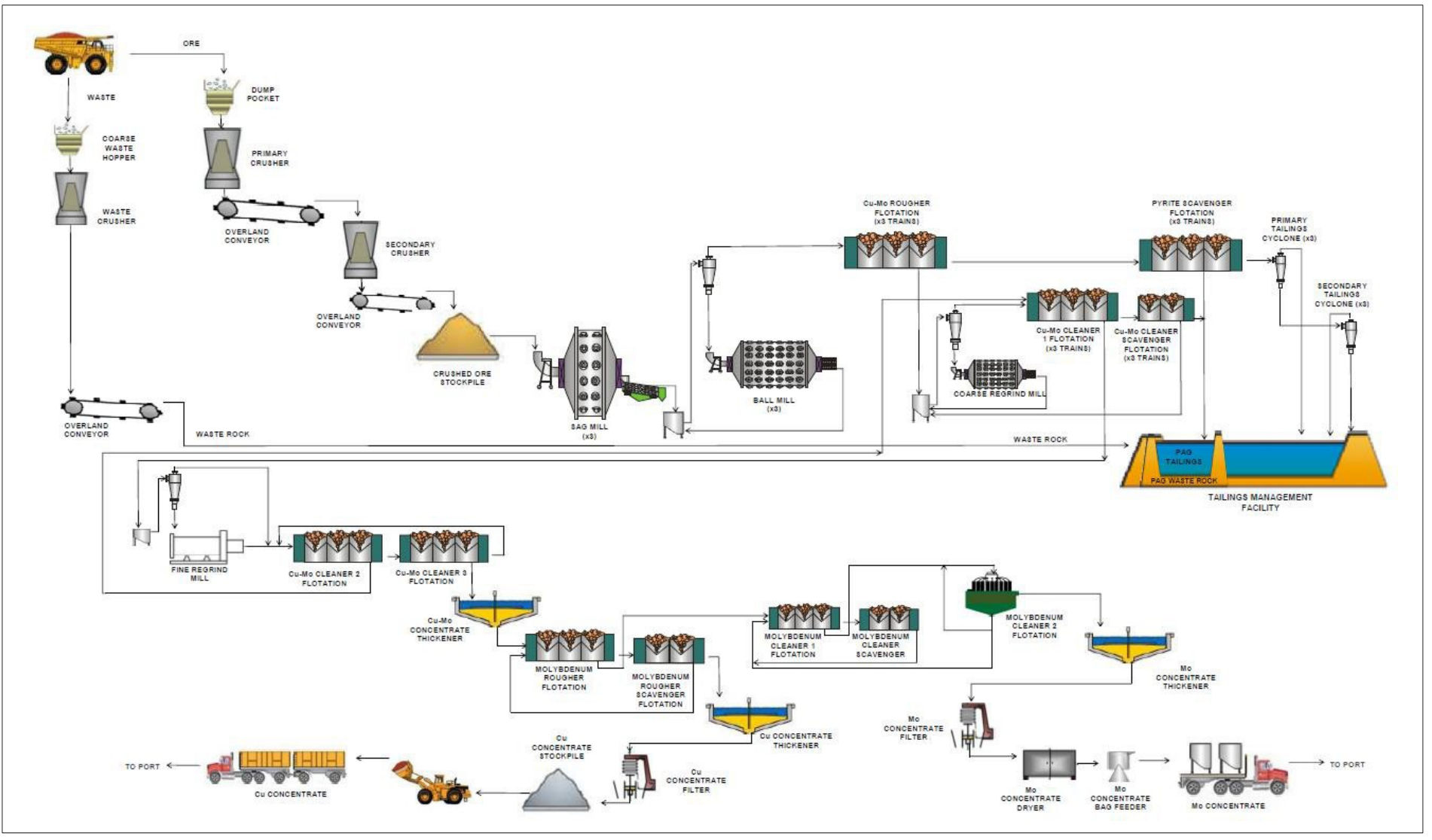
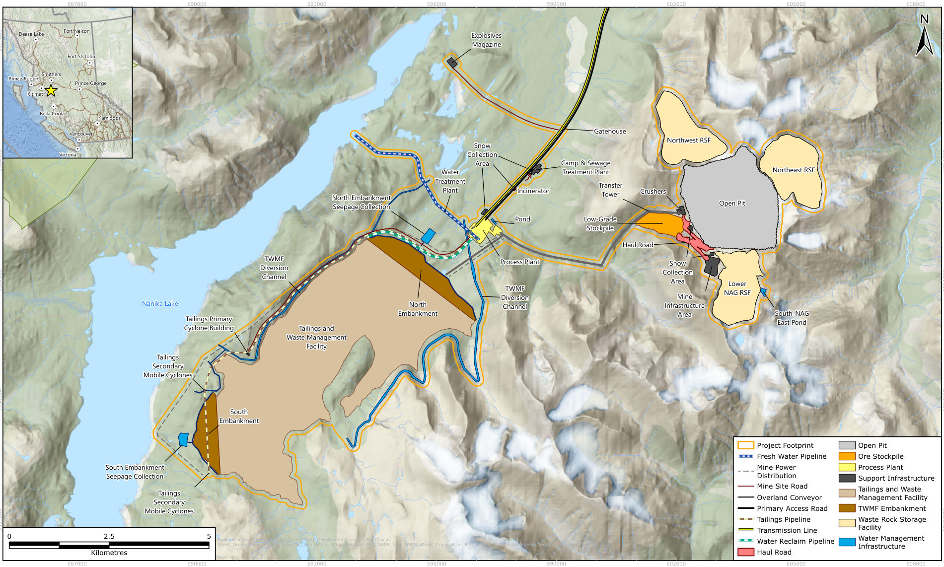
A primary crusher less than 500 metres west of the pit feeds an overland conveyor that runs about 5.6 km downhill to the mill. The mill sits about 400 metres below the crusher, near the tailings facility. A further 1.7 km conveyor leg carries acid-generating waste rock from the plant to the tailings facility; the whole conveyor route is 7.3 km. The company considered trucking ore and waste instead and rejected it for its greenhouse gas emissions and larger footprint. Source: IPD, p. 4-4; IPD, p. 4-8; IPD, p. 4-2; IPD, p. 4-19, Table 4.2-1.
The mill is a conventional flotation plant with semi-autogenous grinding (SAG) and ball mills. Its nameplate capacity is 120,000 tonnes a day. Heap leaching was not considered "due to its increased environmental risk". Source: IPD, p. 4-5; IPD, p. 4-19, Table 4.2-1.
| Product | Average a year | Over the mine life |
|---|---|---|
| Copper | 176 million lb | 4.9 billion lb |
| Molybdenum | 21 million lb | 602 million lb |
| Silver | 3 million oz | 89 million oz |
| Gold | 16,000 oz | 439,000 oz |
Source: IPD, p. 4-5; IPD, p. 3-1. The company states that at this rate Berg "would become Canada's second-largest copper mine and its largest molybdenum mine". That is the company's claim; the IPD gives no comparison data.
Site layout
Phases and durations
| Phase | Duration | What happens |
|---|---|---|
| Site preparation and construction | 3 years | Clearing, soil stripping, roads, camp, plant, first lifts of the tailings dams, and pre-production mining of about 304 million tonnes of waste and 23 million tonnes of ore. Source: IPD, p. 4-21. |
| Operations | 28 years | Mining and milling at about 120,000 tonnes a day; the tailings dams are raised as needed. Source: IPD, p. 4-20, Table 4.3-1; IPD, p. 4-22. |
| Closure | 2 years | Partial backfill and flooding of the pit, removal of buildings, capping and revegetation of the tailings beach. Source: IPD, p. 4-23. |
| Post-closure | open | Care and maintenance "until conditions in permits are met". Source: IPD, p. 4-20, Table 4.3-1. |
The company counts the pit's life as 31 years, including the three years of pre-production mining, and notes that further exploration may lengthen operations. It estimates closure costs at about $236 million, the starting figure for the security bond required under BC's Mines Act. Source: IPD, p. 4-4; IPD, p. 4-20; IPD, p. 4-22.
Power and the transmission line
The PFS assumes power from the BC Hydro grid through a new 230 kV transmission line to the Telkwa substation, just outside Houston on Hungry Hill. The route generally follows the mine access road, existing forest service roads and rights of way. Surge describes the route as flexible: it is running a trade-off study with several First Nations that may consider other connection points, and expects to finish it before the Detailed Project Description. Source: IPD, p. 4-18; IPD, p. 4-20, Table 4.2-1.
- A Nation-led study. Surge and Yinka Dene Economic Development Limited Partnership, the economic arm of Wet'suwet'en First Nation, applied to Natural Resources Canada for a First Nation-led assessment of power options. The application was conditionally approved in April 2026. Source: IPD, p. 6-18.
- Demand. The company's table shows electricity use of 1,042 gigawatt hours (GWh) in Year 1, rising to 1,538 GWh in Year 4 and easing to 1,369 GWh in Year 28. Source: IPD, p. 4-30, Table 4.5-3; IPD, p. 4-31.
- Land crossed. The study corridor is 250 metres either side of the centreline; the final right of way would be about 50 metres wide. The corridor partly overlaps 103 private properties, most between Houston and the substation, and 15 active water licences. Source: IPD, p. 9-2; IPD, p. 9-3, Table 9.2-1.
- Near reserves and parks. Two Wet'suwet'en First Nation reserves, Felix George 7 and Gaichbin 8, lie less than 1 km from the line, and Klagookchew 9 lies 1 km from it. The line runs beside the southeastern boundary of Nenikëkh/Nanika-Kidprice Provincial Park along an existing road. Source: IPD, p. 3-8, Table 3.2-2.
- A House territory. The House of Anaskaski states that its territory, House Territory Code W06, overlaps the proposed transmission line. Source: Anaskaski House notice, Oct 14, 2026, p. 1.
Roads and concentrate haulage
Access is by the Morice and Sibola forest service roads, which the IPD excludes from the project because Surge does not own or operate them. A new 17 km access road from the end of the Sibola road around Mt. Ney to the plant is being permitted for advanced exploration, "prior to and separate from the EA". Inside the site, a 5.5 km road follows the conveyors to the pit. Source: IPD, p. 4-2; IPD, p. 4-18.
Third parties are to truck the concentrates to rail load-outs on Highway 16 or to existing ports. Copper concentrate is to travel in bulk trucks and molybdenum concentrate in bags inside shipping containers. The IPD places this haulage outside Surge's "care and control". Source: IPD, p. 3-11; IPD, p. 4-19, Table 4.2-1.
Our assessment. We assess that the IPD draws its boundary narrowly at the roads. The forest service roads, the 17 km access road and the concentrate trucking all sit outside the project as described. Table 10-1 of the same document nevertheless lists heavier truck traffic on the Morice and Sibola roads as a source of noise, dust and wildlife collisions, so these effects are likely to return as scoping questions. Source: IPD, p. 4-18; IPD, p. 10-2; IPD, p. 10-6; IPD, p. 10-8.
Workforce and camp
| Phase | Peak | Make-up |
|---|---|---|
| Construction (Year -1) | 1,060 | 460 mine operations staff (413 hourly, 47 salaried) and 600 construction workers Source: IPD, p. 4-24. |
| Operations (Year 5) | 783 | 550 mining personnel (499 hourly, 51 salaried) and 233 plant personnel (220 hourly, 13 salaried) Source: IPD, p. 4-22; IPD, p. 4-24. |
The mine runs two 12-hour shifts a day. An on-site camp of about 6.5 hectares is to house about 550 people over the mine life, sized up during construction to hold the peak workforce. Surge targets at least half of the workforce from the local and regional area. Source: IPD, p. 4-24; IPD, p. 4-25.
The company also estimates more than 20,000 person-years of employment, more than $3.2 billion in wages, and about $8.3 billion in net taxes, of which about $5.9 billion goes to BC and $2.5 billion to Canada. Initial capital is about $4.7 billion and sustaining capital $1.7 billion. Source: IPD, p. 3-1; IPD, p. 3-3.
Where the figures disagree
The IPD is a first description, and several of its numbers differ from one section to another. These are the differences we found on the mine plan; others appear on the water, tailings and environment pages.
- Waste rock. 2,409 million tonnes on page 1-3 and 2,408 million tonnes on page 4-4. Source: IPD, p. 1-3; IPD, p. 4-4.
- Annual mill feed. 43.2 million tonnes a year on page 1-3 and 43.8 million tonnes a year on page 4-5. We note that 120,000 tonnes a day for 365 days is 43.8 million tonnes, and 43.2 million tonnes matches 360 days; the IPD does not explain the difference. Source: IPD, p. 1-3; IPD, p. 4-5.
- Workforce. Section 4.4 gives peaks of 1,060 in construction and 783 in operations. Table 10-1 gives about 1,650 construction jobs and 550 operations jobs. Source: IPD, p. 4-24; IPD, p. 10-7; IPD, p. 10-8.
- Claim area. Section 3.3 gives about 41,895 hectares of claims plus 6,324 hectares under option; Table 10-1 refers to a "34,798 ha mineral claim area". Source: IPD, p. 3-10; IPD, p. 10-9.
Sources
- Surge Copper, Initial Project Description and Engagement Plan, September 2026 (195 pages)
- House of Anaskaski, notice of participation, Oct 14, 2026
Page references give the printed page label; each link opens the PDF at that page.